 Re: CA/OR/WA 04/09�04/25, 2010 - 59 LHs, 2 LShips, 9 Fresnels, 2 Faux LHs, 4 Canadian LHs
#68607
07/11/10 01:52 AM Re: CA/OR/WA 04/09�04/25, 2010 - 59 LHs, 2 LShips, 9 Fresnels, 2 Faux LHs, 4 Canadian LHs
#68607
07/11/10 01:52 AM
|
Joined: Dec 2002
Posts: 1,964
sandy
 OP
OP
Cruise Director
|
|
OP
Cruise Director
Joined: Dec 2002
Posts: 1,964 |
Next flyover was Lime Kiln Lighthouse: 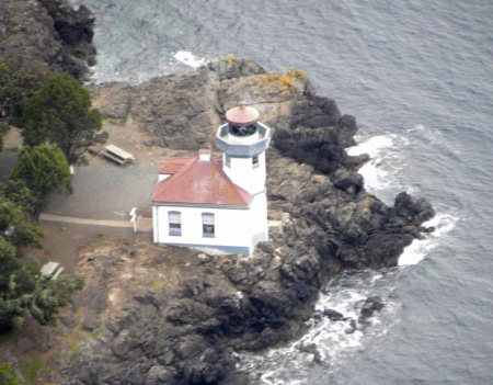 Located on the west side of San Juan Island, the largest island of the large group of islands that form the San Juan Islands in the northwest corner of Washington State. The remains of the limekilns built nearby in the 1860s that lie just north of the lighthouse are where it gets its name from. The last major light established in Washington, Lime Kiln began operations in 1914 and marked the waterways of the entrance to Haro Strait, a major shipping route to Vancouver, BC. Updated in 1919 with a 38' octagonal concrete tower rising from the fog signal building, its 4th-Order Fresnel lens was first exhibited from the new tower on June 30, 1919. The lighthouse did not receive electricity until the 1940s, after WW II.. The Coast Guard automated the Lime Kiln Lighthouse in August 1962, using photoelectric cells to turn the light on at dusk and off during daylight hours. In 1985, the lighthouse and surrounding sea were dedicated as a whale sanctuary and research station for marine mammal scientists. In 1998, the drum lens was replaced with a modern optic, flashing a white light once every 10 seconds. Sitting on the rocky shoreline at a height of 55 feet, the beacon is visible for 17 miles. Next we photographed Discovery Island Light, Vancouver, British Columbia: 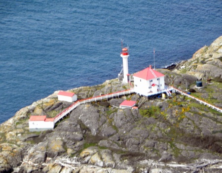 Built in 1886 on Pandora Hill, the highest point on Discovery Island in the province of British Columbia, Canada, the daughter of the first keeper, Mary Ann Croft, became the very first female lighthouse keeper in Canada, following the death of her father in 1902. Mary Ann retired as the keeper in 1932, having spent a total of 46 years living on Discovery Island, 30 of those years as keeper. In 1996 the lighthouse destaffed and automated, having been manned for 110 years. The foghorn was deactivated and removed from the station in 2004. Nobody lives on the island the lighthouse buildings are deteriorating. Next was Race Rocks Light, Vancouver, British Columbia: 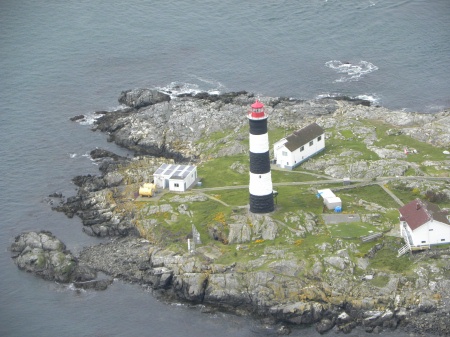 One of two lighthouses (Fisgard is the other one) built on the west coast of Canada, financed by the British Government, and shone for the first time in 1860. It is the only lighthouse on that coast built of granite purportedly quarried in Scotland, and topped with sandstone quarried on Gabriola Island. The Islands of Race Rocks are located just off the southern tip of Vancouver Island, about 10 miles southwest of Victoria, British Columbia. Built between 1958 and 1860, Race Rocks Light was illuminated on December 26, 1860, six weeks after the smaller Fisgard Island Lighthouse built at the entrance to Esquimal Harbour near Victoria. Both lighthouses celebrated their sesquicentennial in 2010. Race Rocks Light is an 80' cylindrical tower with black and white bands that flashes a white light every 10 seconds. Its foghorn sounds 3 blasts at one minute intervals. Automated since 1997, restoration of the interior and exterior of the historic light tower was carried out in 2009. Next was Sheringham Point, Vancouver, British Columbia: 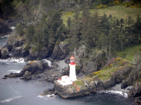 Built to guide mariners entering the Strait of Juan de Fuca from the north between Carmanah Point and Race Rocks lighthouses, Sheringham Point and the Lighthouse are named for a commander of the Royal Navy whose accomplishments included surveying the south coast of England and Wales. The hexagonal reinforced concrete lighthouse stands 84' high, and has a 7' lantern room that housed a 3rd-Order triple flashing Fresnel lens. Lit for the first time on September 30, 1912, the station�s close proximity to Victoria proved beneficial to keeping staff for long periods. Destaffed in 1989, its 3rd-Order Fresnel lens was removed from the tower in 1978 and can be seen at the Sooke Region Museum. The Sheringham Point Lighthouse Preservation Society was formed in 2003 to work for the preservation of the tower and the creation of a public park on the surrounding 10 acres. Conservation groups are petitioning the government to purchase other acreage around the lighthouse to prevent private developers from constructing homes. Last flyover was Cape Flattery: 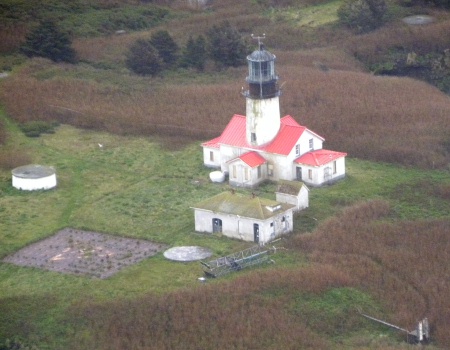 Captain James Cook visited the waters off the northwestern tip of the Olympic Peninsula in 1778. An opening along the coast had �flattered� Cook into thinking he had located a harbor or passage, prompting him to name the place Cape Flattery. He noted in his logbook, �In this very latitude geographers have placed the pretended Strait of Juan de Fuca. But nothing of that kind presented itself to our view, nor is it probably that any such thing ever existed.� Ten years later, several explorers confirmed the existence of the Strait of Juan de Fuca. Occupying America�s northernmost point, Cape Flattery Lighthouses was part of the second batch of 8 lighthouses to be completed on the west coast. Built on Tatooche Island (named for the Chief of the Makah Indians), a small island a half mile off Cape Flattery in 1857, the tower protrudes through the roof of a 1-1/2-story dwelling. The tower was large enough to house the 1st-Order Fresnel lens�ordered for Point Loma Lighthouse and found to be too large. It was first illuminated on December 28, 1857, 2 weeks after the New Dungeness Lighthouse. Its 1st-Order Fresnel was replaced by a 4th-Order Fresnel sometime in 1932, and a Vega Rotating Beacon served as the light source in recent years. An isolated station, keepers hired local Indians to transport people, supplies, and mail to the island. The station included a fog signal building (1872), a 33,000-gallon cistern (1875), a duplex (1876[?]) to house keeper and assistant keeper and their respective families. The dwelling in the lighthouse was used for storage after the duplex was built, as its conditions were such that it was uninhabitable and it was not until 1894 that it was made habitable again. Automated in 1977, substantial maintenance and repair work was performed on the island�s remaining structures in 1999. A 3-phase clean-up was completed by the Coast Guard in September of 2009. Removal of old generators and fuel tanks and erection of a new 30' skeletal tower that will require a checkup annually. The decommissioned Cape Flattery Lighthouse will eventually be turned over to the Makah Indian Tribe. Last stop for the day was by car and Dofflemeyer Point Light: 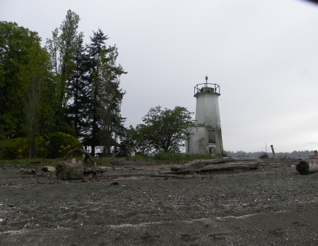 Dofflemeyer Point defines the eastern side of the entrance to Bud Inlet. A lens lantern on top of a 12' stake was established at the point in 1887. The light was upgraded to the present 30' pyramidal concrete tower in 1934. Local residents were contracted to care for the light and activate the fog signal. The light was automated by the Coast Guard in the 1960s, but the fog signal still required manual activation-- the fog signal was not automated until 1987. Coast Guard personnel aboard a buoy tender maintain the signal today Saturday, 04/24/2010: 1 lighthouse, 560 miles (round trip), 9.5 hours: 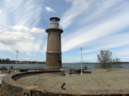 Clover Island is located off the shoreline of the Columbia River in Kennewick, WA. A new 62' tall lighthouse now helps to define the 17-acre island. Part of a plan to develop the 28-acre span of shoreline adjacent to Clover island that will eventually include a carousel and mixed commercial, retail, and residential development. The lighthouse has a functioning solar powered LED beacon and will serve as a private aid to navigation. Well, that�s a recap of our journey. Hope you enjoyed your trip. . . . Sandy
|
|
|
|
Entire Thread
|
 CA/OR/WA 04/09�04/25, 2010 - 59 LHs, 2 LShips, 9 Fresnels, 2 Faux LHs, 4 Canadian LHs
|
sandy
|
06/20/10 11:39 PM
|
|
Re: CA/OR/WA 04/09�04/25, 2010 - 59 LHs, 2 LShips, 9 Fresnels, 2 Faux LHs, 4 Canadian LHs
|
sandy
|
06/20/10 11:39 PM
|
|
Re: CA/OR/WA 04/09�04/25, 2010 - 59 LHs, 2 LShips, 9 Fresnels, 2 Faux LHs, 4 Canadian LHs
|
sandy
|
06/20/10 11:40 PM
|
|
Re: CA/OR/WA 04/09�04/25, 2010 - 59 LHs, 2 LShips, 9 Fresnels, 2 Faux LHs, 4 Canadian LHs
|
sandy
|
06/20/10 11:40 PM
|
|
Re: CA/OR/WA 04/09�04/25, 2010 - 59 LHs, 2 LShips, 9 Fresnels, 2 Faux LHs, 4 Canadian LHs
|
sandy
|
06/20/10 11:40 PM
|
|
Re: CA/OR/WA 04/09�04/25, 2010 - 59 LHs, 2 LShips, 9 Fresnels, 2 Faux LHs, 4 Canadian LHs
|
sandy
|
06/20/10 11:52 PM
|
|
Re: CA/OR/WA 04/09�04/25, 2010 - 59 LHs, 2 LShips, 9 Fresnels, 2 Faux LHs, 4 Canadian LHs
|
sandy
|
06/20/10 11:52 PM
|
|
Re: CA/OR/WA 04/09�04/25, 2010 - 59 LHs, 2 LShips, 9 Fresnels, 2 Faux LHs, 4 Canadian LHs
|
sandy
|
06/20/10 11:52 PM
|
|
Re: CA/OR/WA 04/09�04/25, 2010 - 59 LHs, 2 LShips, 9 Fresnels, 2 Faux LHs, 4 Canadian LHs
|
sandy
|
06/21/10 12:07 AM
|
|
Re: CA/OR/WA 04/09�04/25, 2010 - 59 LHs, 2 LShips, 9 Fresnels, 2 Faux LHs, 4 Canadian LHs
|
WackoPaul
|
06/21/10 02:21 AM
|
|
Re: CA/OR/WA 04/09�04/25, 2010 - 59 LHs, 2 LShips, 9 Fresnels, 2 Faux LHs, 4 Canadian LHs
|
Lorie Roe
|
06/21/10 03:50 PM
|
|
Re: CA/OR/WA 04/09�04/25, 2010 - 59 LHs, 2 LShips, 9 Fresnels, 2 Faux LHs, 4 Canadian LHs
|
kory63
|
06/21/10 04:18 PM
|
|
Re: CA/OR/WA 04/09�04/25, 2010 - 59 LHs, 2 LShips, 9 Fresnels, 2 Faux LHs, 4 Canadian LHs
|
wvlights0
|
06/21/10 07:03 PM
|
|
Re: CA/OR/WA 04/09�04/25, 2010 - 59 LHs, 2 LShips, 9 Fresnels, 2 Faux LHs, 4 Canadian LHs
|
sandy
|
06/21/10 10:41 PM
|
|
Re: CA/OR/WA 04/09�04/25, 2010 - 59 LHs, 2 LShips, 9 Fresnels, 2 Faux LHs, 4 Canadian LHs
|
MrsTLC
|
06/21/10 10:49 PM
|
|
Re: CA/OR/WA 04/09�04/25, 2010 - 59 LHs, 2 LShips, 9 Fresnels, 2 Faux LHs, 4 Canadian LHs
|
Bill and Judy
|
06/22/10 02:15 AM
|
|
Re: CA/OR/WA 04/09�04/25, 2010 - 59 LHs, 2 LShips, 9 Fresnels, 2 Faux LHs, 4 Canadian LHs
|
rscroope
|
06/22/10 06:51 PM
|
|
Re: CA/OR/WA 04/09�04/25, 2010 - 59 LHs, 2 LShips, 9 Fresnels, 2 Faux LHs, 4 Canadian LHs
|
sandy
|
06/22/10 11:49 PM
|
|
Re: CA/OR/WA 04/09�04/25, 2010 - 59 LHs, 2 LShips, 9 Fresnels, 2 Faux LHs, 4 Canadian LHs
|
Lighthouse Loon
|
06/23/10 12:06 AM
|
|
Re: CA/OR/WA 04/09�04/25, 2010 - 59 LHs, 2 LShips, 9 Fresnels, 2 Faux LHs, 4 Canadian LHs
|
sandy
|
06/30/10 06:59 AM
|
|
Re: CA/OR/WA 04/09�04/25, 2010 - 59 LHs, 2 LShips, 9 Fresnels, 2 Faux LHs, 4 Canadian LHs
|
sandy
|
06/30/10 07:00 AM
|
|
Re: CA/OR/WA 04/09�04/25, 2010 - 59 LHs, 2 LShips, 9 Fresnels, 2 Faux LHs, 4 Canadian LHs
|
WackoPaul
|
06/30/10 03:50 PM
|
|
Re: CA/OR/WA 04/09�04/25, 2010 - 59 LHs, 2 LShips, 9 Fresnels, 2 Faux LHs, 4 Canadian LHs
|
rscroope
|
06/30/10 07:57 PM
|
|
Re: CA/OR/WA 04/09�04/25, 2010 - 59 LHs, 2 LShips, 9 Fresnels, 2 Faux LHs, 4 Canadian LHs
|
wvlights0
|
07/01/10 02:45 AM
|
|
Re: CA/OR/WA 04/09�04/25, 2010 - 59 LHs, 2 LShips, 9 Fresnels, 2 Faux LHs, 4 Canadian LHs
|
sandy
|
07/01/10 03:53 AM
|
|
Re: CA/OR/WA 04/09�04/25, 2010 - 59 LHs, 2 LShips, 9 Fresnels, 2 Faux LHs, 4 Canadian LHs
|
fra02441
|
07/01/10 02:04 PM
|
|
Re: CA/OR/WA 04/09�04/25, 2010 - 59 LHs, 2 LShips, 9 Fresnels, 2 Faux LHs, 4 Canadian LHs
|
sandy
|
07/02/10 07:06 AM
|
|
Re: CA/OR/WA 04/09�04/25, 2010 - 59 LHs, 2 LShips, 9 Fresnels, 2 Faux LHs, 4 Canadian LHs
|
sandy
|
07/11/10 05:52 AM
|
|
Re: CA/OR/WA 04/09�04/25, 2010 - 59 LHs, 2 LShips, 9 Fresnels, 2 Faux LHs, 4 Canadian LHs
|
sandy
|
07/11/10 05:52 AM
|
|
Re: CA/OR/WA 04/09�04/25, 2010 - 59 LHs, 2 LShips, 9 Fresnels, 2 Faux LHs, 4 Canadian LHs
|
sandy
|
07/11/10 05:52 AM
|
|
Re: CA/OR/WA 04/09�04/25, 2010 - 59 LHs, 2 LShips, 9 Fresnels, 2 Faux LHs, 4 Canadian LHs
|
WackoPaul
|
07/11/10 04:44 PM
|
|
|
|
Forums39
Topics16,978
Posts184,640
Members2,579
| |
Most Online10,155
Jan 14th, 2020
|
|
|
0 registered members (),
1,186
guests, and 1
spider. |
|
Key:
Admin,
Global Mod,
Mod
|
|
|
