Friday, 04/23/2010: 2 LHs by car, 8 US LHs, 4 Canadian LHs by air: First stop today was to locate and photograph the former Ediz Hook Lighthouse:
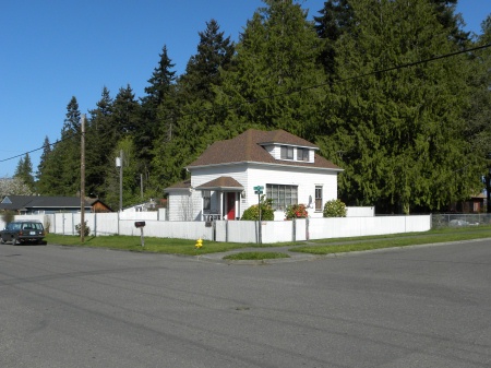
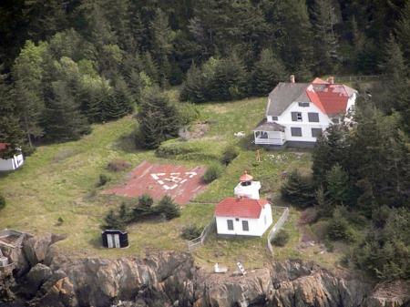
The Port Angeles Harbor is the deepest harbor in the northwest and is protected by a 3-1/2 mile long spit called Ediz Hook. As early as 1862 driftwood was burned on a tripod to provide light for navigation. The first Ediz Hook Lighthouse resembled a country schoolhouse. It was a 2-story dwelling with a pitched roof and a small tower protruding from one end. A fixed, 5th-Order Fresnel lens was first shown on April 2, 1865. This dwelling/lighthouse was in need of repairs by the turn of the century and mariners repeatedly complained about the fog bell�s coverage, or lack thereof. To solve both problems, in 1908 a fog signal building with an attached octagonal tower was completed near the old lighthouse and a new lighthouse similar in style to Mukilteo Lighthouse was built. The lantern room and lens were removed from the 1865 lighthouse and placed atop the new tower. The tower was removed from the old lighthouse, it was remodeled, and continued to serve as a dwelling together with a newer structure built next to it.
The second Ediz Hook Lighthouse served until 1946. It was sold and barged across the harbor to Port Angeles where it is a private residence.
Next stop was the Wm. R. Fairchild International Airport and Rick Mowbray, Charter Pilot:
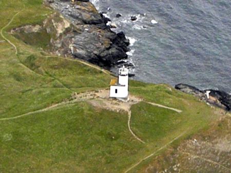
First view was of New Dungeness Light:
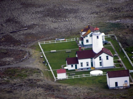
Nearly a century and a half old, New Dungeness Lighthouse still guides ships past its treacherous spit in the Strait of San Juan de Fuca. The 6-mile flat spit is barely visible from a distance and is one of the largest natural spits in the world. On December 14, 1857 the 3rd-Order Fresnel lens from the New Dungeness Lighthouse, the second lighthouse established in the Washington territory (the first was Cape Disappointment), was exhibited for the first time.
The original New Dungeness lighthouse was a 1-1/2-story Cape Cod style duplex with a tower rising from the center of the roof. The tower stood at 92' and its bottom half was painted white, the top half painted black, and the lantern room was a bright red. Nicknamed �Shipwreck Spit,� the spit also had a long history as an Indian battleground. Over time the tower developed structural cracks and was shortened by 30' in 1927. The original lantern room and lens were too large for the tower, so they were replaced by the lantern room and 4th-Order Fresnel lens from the decommissioned Admiralty Head. The remodeled tower was painted white from top to bottom which is the current color.
A modern optic was installed in 1976 and the 4th-Order Fresnel can now be seen at the Coast Guard Museum in Seattle. New Dungeness was the last Coast Guard manned lighthouse on the west coast. The last keeper left in 1994 and the Coast Guard planned to board up the lighthouse. Volunteers with the Coast Guard Auxiliary and members of the New Dungeness Chapter of the USLHS devised a plan that has literally saved the lighthouse.
The Chapter leases the station from the Coast Guard and manages a program where volunteers stay at the lighthouse for a week, maintaining the structure and greeting visitors. The program is very popular�so much so that the reservation list is two years long. Located in the Dungeness Wildlife Refuge, the refuge is haven to more than 250 species of birds, 41 species of land mammals, and 8 species of marine mammals.
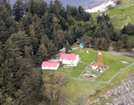
Next flyover was Marrowstone Point:
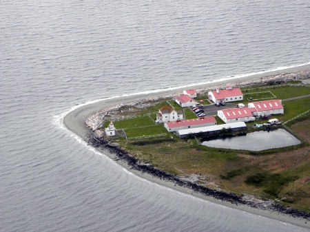
Named for the soft clay visible in the bluffs above Marrowstone Point, it forms the eastern entrance to Port Townsend Bay and was first marked by a lens lantern on a pole in 1888. A fog bell was added to the station in 1896, and a 1-1/2-story dwelling was constructed on the point to house the keeper and his family. In 1902, the light was placed on the small, concrete structure.
Fort Flagler was built on the bluff above the point in 1907. It became the 3rd active fort guarding Admiralty Inlet. Together with the guns at Fort Casey on Admiralty Head, and those at Fort Worden near Point Wilson, the batteries at Fort Flagler formed the �Triangle of Fire,� to prevent hostile vessels from entering Puget Sound.
Mariners complained that the fog bell at the point was often inaudible. Different experiments proved inadequate until the small, square cement building seen on the far left in the photograph was outfitted with three large trumpets was put into service in 1918. Eventually, the light was mounted on top of the fog signal building. Automated in 1962, the keeper�s dwelling is now home to the Marrowstone Marine Field Station, and Fort Flagler, now a state park, includes a military museum.
Next was Bush Point:
Located south of Admiralty Head on Whidbey Island, this small lighthouse has been guiding mariners through the middle reaches of Admiralty Inlet into the waters of Puget Sound since 1933. Before its construction, residents hung a kerosene lantern on a pole warning passing ships on dark nights.
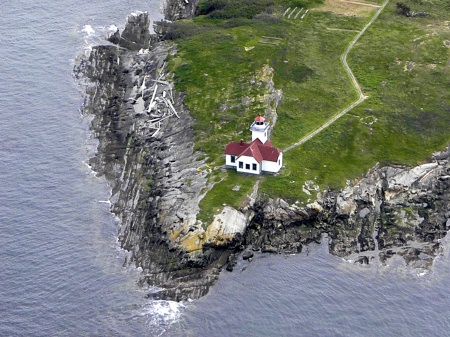
Next was Burrows Island:
Located on the southwestern end of Burrows Island, the lighthouse built there in 1906 warns of the dangers of nearby Dennis Shoal and Lawson Reef where strong eddy lines and tide rips can be unpredictable. The wood-framed building is similar to Mukilteo Lighthouse in design. The 34' tall square tower is attached to a fog signal building which originally held a Daboli trumpet fog signal.
The 4th-Order Fresnel lens was first lit on April 1, 1906. The light station was built on one of the few level spots on the island and originally, the station included the combination light tower and fog signal building, a keepers� duplex, a boathouse, and a derrick. A bungalow was built later north of the duplex to house an additional keeper. A power plant was added when electricity arrived. Fuel to keep the generators going was delivered every 8 months.
Automated in 1972, a modern optic replaced the Fresnel lens in the early 1990s. A helicopter landing pad now stands where the keeper�s bungalow was located. The original Fresnel lens is at the Coast Guard Station in Port Angeles. Forty acres of the island now make up Burrows Island State Park and includes the light station and 1,000' of shoreline. Offered to an eligible entity under the National Historic Lighthouse Preservation Act in 2006, the National Park Service has yet to announce the result of the review process on the applications received.
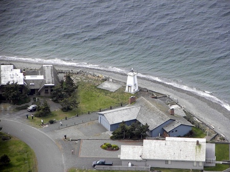
Next was Cattle Point Lighthouse:
Located near Friday Harbor on San Juan Island, Cattle Point Light is in danger of collapse due to erosion. Unlike other lighthouses, this modern 34', octagonal, concrete, 1935-built structure had neither a lantern room nor a lighthouse keeper. The site was marked as early as 1888 by a post lantern and, in 1921, the US Navy installed a radio compass station nearby, which is now an interpretative center.
The site was used to graze cattle, and at one time a ship loaded with cattle was stranded nearby and the crew forced the cattle to swim to the point�hence the name.
The Coast Guard owns the lighthouse and an article in the May, 2010 edition of Lighthouse Digest indicates the Guard will take the necessary steps in 2010 to save the lighthouse. They intend to drive in piles of thin interlocking sheets of steel to obtain a continuous barrier around the lighthouse, which will then be reinforced by concrete.
Next flyover was Patos Island Light:
The northernmost island of the now-American San Juan Islands, Isla de Patos (�Island of Ducks�) was so-named by Spanish explorers in 1792. The lighthouse is located at Alden Point on the western tip of the island. The original station was a post light and 3rd-Class Daboli trumpet fog signal. The post light was used as a navigational aid to steamships traveling from British Columbia to Alaska through the Boundary Pass waterway adjacent to the island and was first lit on November 30, 1893.
Improved in 1908, a 38' tower housed a 4th-Order Fresnel lens. Automated in 1974, the Fresnel lens which was also used at the Alki Point Lighthouse, is now in private ownership in Oregon. The original keeper�s quarters were torn down in 1958 and replaced with a 2-story duplex for the Coast Guard attendants. After the Bureau of Land Management assumed control of Patos Island in 2005, the duplex was also torn down as it had become a safety hazard due to deterioration and vandalism.
Next was East Point Light Station (Saturna Island), British Columbia:
This Canadian lighthouse and the United States� Patos island Light, bracket the transition between Boundary Pass, which follows the U.S./Canadian border for 14 miles, and the Strait of Georgia. The first lighthouse, named Saturna Island, was a square pyramidal wooden tower, 60' high, with an attached dwelling. A revolving white light was first displayed on January 1, 1888. Its flash attained its greatest brilliancy every 30 seconds, and had a focal plane of 140' above the high water mark. Mariners were warned not to approach the light within 1-1/2 miles from the northerly and westerly directions to avoid dangerous ground. A post light was established on Patos Island, across Boundary Pass, in 1893.
The present red, steel, skeletal tower and new keeper�s dwelling were built in 1948. A third keeper�s dwelling was built in 1960 and was in use until the station was destaffed in 1996. The station was transferred to Parks Canada and added to the new Gulf Island National Park Reserve in 2006. The tower continues to display a pair of lights to guide mariners. The tower, a keeper�s dwelling, and a fog alarm building remain standing at East Point. The keeper�s dwelling are used as housing for park staff; the fog alarm building serves as a heritage center featuring displays and information related to the heritage of East Point.


