 Re: CA/OR/WA 04/09�04/25, 2010 - 59 LHs, 2 LShips, 9 Fresnels, 2 Faux LHs, 4 Canadian LHs
#68582
06/20/10 07:40 PM Re: CA/OR/WA 04/09�04/25, 2010 - 59 LHs, 2 LShips, 9 Fresnels, 2 Faux LHs, 4 Canadian LHs
#68582
06/20/10 07:40 PM
|
Joined: Dec 2002
Posts: 1,964
sandy
 OP
OP
Cruise Director
|
|
OP
Cruise Director
Joined: Dec 2002
Posts: 1,964 |
We were on the road by 8 AM, Saturday, April 17. The Plan of the Day was to drive 175 miles and view 10 lighthouses. The first stop was Point Montara Lighthouse: 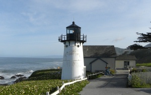 This unique lighthouse is the only one currently in existence that has served on both coasts. From 1881 to 1922 it was served as the Mayo Beach Light and overlooked Wellfleet Harbour in Massachusetts. It was believed that it had been destroyed after the light was discontinued in 1922, but while conducting research for a lighthouse book, the author happened upon a 1928 photograph of a tower in Yerba Buena, CA that had an inscription that read, �This tower formerly used at Mayo Beach, 2d District.� She delved into the National Archives and found proof that this tower was sent from Massachusetts to Yerba Buena and then to Point Montara. Altho� only 30' high, this tower is short by most standards, but is excellent for keeping the beam beneath the fog. Next was Quinn�s Lighthouse Restaurant & Pub, formerly Oakland Harbor Lighthouse, located in Oakland, CA: 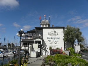 This lighthouse was a nearly square, 2-story structure built on a steel beam decking that rested on support cylinders. It began operating in 1903, and its fog bell came from the original lighthouse that served from 1890 until 1902 when it was determined that marine borers had weakened the wooden pilings that that lighthouse was built on and it was no longer stable. The second Oakland Harbor Lighthouse served until 1966 when an automatic beacon was installed nearby. Its lantern room was shipped to Santa Cruz where it was installed on the Mark Abbott Memorial Lighthouse. The remaining structure was sold to a restaurant firm and transported 6 miles south along the Oakland estuary to its current home. Lightship Relief WLV 605: 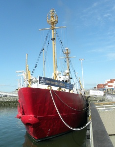 Construction on WLV 605 began in Boothbay Harbor, ME in 1949 and she steamed to her first station, Overfalls, DE, where she served to mark the entrance to Delaware Bay. Since she acted as a mid-channel marker, traffic in and around the lightship was common. In October of 1954, a large tanker staved in the lightship�s bow and knocked it a full quarter mile off station. WLV 605 served in Overfalls until 1960 when she was transferred to the Blunts Reef station off Cape Mendocino, CA. She served there until 1969 when she became the Relief lightship for the west coast and operated out of Astoria, Oregon. Whenever a vessel on one of the four remaining active west coast lightship stations needed to be serviced, WLV 605, displaying RELIEF in white letters on her red hull, would be temporarily anchored at the station. WLV 605 was decommissioned in 1975 and eventually sold to a resident of Woodside, CA in 1977. Following extensive renovations, she was sailed to Half Moon Bay, CA and anchored in the harbor until 1986 when she was donated to the US Lighthouse Society in 1986. In February of 1987, WLV 605 was sailed from Half Moon Bay to the 9th Avenue Terminal in the Oakland Estuary. Volunteers spent thousands of hours and fifteen years restoring her to her 1951 appearance. She was designated a National Historic Landmark in 1990 and was opened to the public in 2002 at her present location, docked alongside FDR�s presidential yacht Potomac. The USLHS received the CA Governor�s Historic Preservation Award in 2003 for its preservation efforts. Next was East Brother Lighthouse: 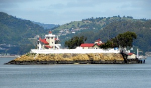 Altho� placed on the National Register of Historic Places in 1971 which prevented the building from being razed, neither the Coast Guard nor other public agencies had funds to maintain or restore the buildings of this station. Receiving little attention for almost 10 years, neglect started taking its toll. A non-profit group, East Brother Light Station, Inc., was formed in1979 to restore the landmark and make it accessible to the public. Government grants, day use fees, and funds received through the operation of the lighthouse as a bed and breakfast are used to maintain the facilities today. Derith (a/k/a Pixie) gave me a wealth of information prior to our leaving for this trip, much of which I was able to use and all of which I am eternally grateful for. However she indicated the only way to see Yerba Buena was from the Oakland/San Francisco Bridge. So, Stan drove one way across while I tried to get pics from the car, and I drove the other way across and he tried. Neither of us was successful (bridge railings were in the way and shooting blind with the camera held out the window and overhead was asking for trouble!) and the car didn�t have a sunroof. Timing was off for us to take a boat ride from Oakland to San Francisco and her suggestion that one of us go on the cruise and the other one meet the cruise in Oakland wasn�t doable�Stan�s the photographer and I won�t drive in big cities or across bridges by myself. We went round and round and back and forth the little island on which the station is located without any sighting and were going to call it a day when he decided to try to find a place across the bay. After all, he has a new toy and that new toy has 24x magnification. So, we found a municipal parking lot and VOILA: 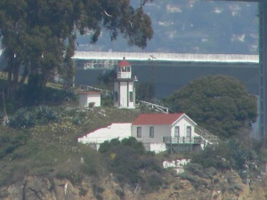 Still active, the keeper�s dwelling is home to a Coast Guard admiral today. Automated in 1958, the southeast part of the island that once served as the district�s lighthouse depot is now home to Coast Guard Group San Francisco and Aids to Navigation Team San Francisco. Next stop was to take pictures of Alcatraz Island Light from the Ghirardelli Square area across the bay: 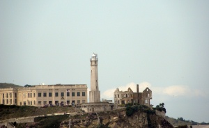 This lighthouse replaced the original 1-1/2-story cottage dwelling that had a tower protruding through the center of the roof. The Alcatraz Citadel, a multi-story fortified barracks finished in 1859 was first used as a prison during the Civil War. The Citadel was razed and in its place, the present cellhouse was built in 1909. It had 600 cells and was reportedly the largest reinforced concrete building in the world. Realizing the new structure would interfere with the operation of the lighthouse, a taller 84', concrete tower was built just south of the original lighthouse. Attached to the base of the tower was a dwelling designed for three keepers and their families. The island served as a military prison until it was acquired by the U.S. Justice Department in 1933 to serve as a federal penitentiary. The penitentiary closed in 1963 and Alcatraz was declared surplus property. The history of this lighthouse and the island on which it stands is quite interesting and includes a bloody escape attempt that resulted in a number of deaths and the execution of two inmates for their role in the killing of two guards, and occupation by 90 Native Americans for 19 months. Only the tall cement tower equipped with a modern beacon stands as a reminder of those who served on the island for over a hundred years. Our 7th stop of the day was to take pictures of what remains of Mile Rocks located 0.4 miles from the closest shore and one mile south of the main shipping channel leading into San Francisco Bay: 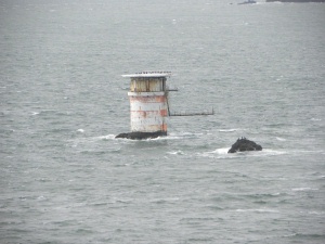 The rock on which the lighthouse was built measured 40' x 30' and a sizeable portion was blasted away to provide a level foundation. 4' thick walls x 35' high made of steel-reinforced concrete were built to form the base of the tower. The cistern and fuel tanks were housed within the base. A 3-tiered steel tower capped by a lantern room gave the appearance of a steel wedding cake. The first tier housed the engines for powering the station�s fog signal; the second tier was composed of 2 stories�an office and day room was on the bottom floor, and 2 bedrooms and a bathroom on the second floor. The third tier was used for storage. The caisson and first tier were oval; the upper tiers and lantern room (its crosshatched window panes protected a 3rd-Order Fresnel lens) were circular. Always considered a �stag station,� there was hardly enough room for the resident four keepers, much less a keeper with family. Transported to the tower by boat, keepers had to snag the Jacob�s Ladder suspended from the tower�s catwalk to begin the 30' ascent. Automation of the lighthouse occurred in 1966 to save money. The Coast Guard dismantled the lantern room and top two tiers prior to automation (despite protests from local officials and residents) and fabricated the top of what remained for use as a helicopter landing pad. Its 3rd-Order Fresnel lens was passed to Old Point Loma where it is housed today. The photograph shown on Lighthouse Friends website of the lighthouse prior to decapitation shows what a striking station it was, especially when compared to how it looks today. Our 8th stop of the day was Fort Point Light, California�s second lighthouse:  Built at the same time as Alcatraz, the first Fort Point Light was completed in 1853 and was a California cottage-style dwelling with a lantern room on the roof. When the US Army decided that the Point was essential to defense of the bay, the 3-month old lighthouse was torn down and Fort Winfield Scott constructed on the site. The 3rd-Order Fresnel lens destined for the first lighthouse was diverted to Point Pinos where it has remained. A 36' wooden tower was constructed on a ledge between the fort and the sea wall. Completed in1855, it housed a 5th-Order lens. Lasting only 8 years due to erosion from the Pacific Ocean, the second lighthouse was removed in 1863. The 27' iron tower built on the roof of the fort placing it 83' above sea level was built in 1864. White with a black lantern room and a black iron spiral staircase to the tower, the tower housed a 4th-Order lens and still stands today. Altho� Fort Point Lighthouse survived the 1906 San Francisco Earthquake, it was made obsolete by the construction of the Golden Gate Bridge--it overshadowed the point and obscured the light. Extinguished in 1934, the keeper�s residences and footbridge that connected their housing at the top of the bluff behind the fort to the roof of the fort was removed. Fort Point is part of the Golden Gate National Recreation Area and protected by the National Park Service.
|
|
|
|
Entire Thread
|
 CA/OR/WA 04/09�04/25, 2010 - 59 LHs, 2 LShips, 9 Fresnels, 2 Faux LHs, 4 Canadian LHs
|
sandy
|
06/20/10 11:39 PM
|
|
Re: CA/OR/WA 04/09�04/25, 2010 - 59 LHs, 2 LShips, 9 Fresnels, 2 Faux LHs, 4 Canadian LHs
|
sandy
|
06/20/10 11:39 PM
|
|
Re: CA/OR/WA 04/09�04/25, 2010 - 59 LHs, 2 LShips, 9 Fresnels, 2 Faux LHs, 4 Canadian LHs
|
sandy
|
06/20/10 11:40 PM
|
|
Re: CA/OR/WA 04/09�04/25, 2010 - 59 LHs, 2 LShips, 9 Fresnels, 2 Faux LHs, 4 Canadian LHs
|
sandy
|
06/20/10 11:40 PM
|
|
Re: CA/OR/WA 04/09�04/25, 2010 - 59 LHs, 2 LShips, 9 Fresnels, 2 Faux LHs, 4 Canadian LHs
|
sandy
|
06/20/10 11:40 PM
|
|
Re: CA/OR/WA 04/09�04/25, 2010 - 59 LHs, 2 LShips, 9 Fresnels, 2 Faux LHs, 4 Canadian LHs
|
sandy
|
06/20/10 11:52 PM
|
|
Re: CA/OR/WA 04/09�04/25, 2010 - 59 LHs, 2 LShips, 9 Fresnels, 2 Faux LHs, 4 Canadian LHs
|
sandy
|
06/20/10 11:52 PM
|
|
Re: CA/OR/WA 04/09�04/25, 2010 - 59 LHs, 2 LShips, 9 Fresnels, 2 Faux LHs, 4 Canadian LHs
|
sandy
|
06/20/10 11:52 PM
|
|
Re: CA/OR/WA 04/09�04/25, 2010 - 59 LHs, 2 LShips, 9 Fresnels, 2 Faux LHs, 4 Canadian LHs
|
sandy
|
06/21/10 12:07 AM
|
|
Re: CA/OR/WA 04/09�04/25, 2010 - 59 LHs, 2 LShips, 9 Fresnels, 2 Faux LHs, 4 Canadian LHs
|
WackoPaul
|
06/21/10 02:21 AM
|
|
Re: CA/OR/WA 04/09�04/25, 2010 - 59 LHs, 2 LShips, 9 Fresnels, 2 Faux LHs, 4 Canadian LHs
|
Lorie Roe
|
06/21/10 03:50 PM
|
|
Re: CA/OR/WA 04/09�04/25, 2010 - 59 LHs, 2 LShips, 9 Fresnels, 2 Faux LHs, 4 Canadian LHs
|
kory63
|
06/21/10 04:18 PM
|
|
Re: CA/OR/WA 04/09�04/25, 2010 - 59 LHs, 2 LShips, 9 Fresnels, 2 Faux LHs, 4 Canadian LHs
|
wvlights0
|
06/21/10 07:03 PM
|
|
Re: CA/OR/WA 04/09�04/25, 2010 - 59 LHs, 2 LShips, 9 Fresnels, 2 Faux LHs, 4 Canadian LHs
|
sandy
|
06/21/10 10:41 PM
|
|
Re: CA/OR/WA 04/09�04/25, 2010 - 59 LHs, 2 LShips, 9 Fresnels, 2 Faux LHs, 4 Canadian LHs
|
MrsTLC
|
06/21/10 10:49 PM
|
|
Re: CA/OR/WA 04/09�04/25, 2010 - 59 LHs, 2 LShips, 9 Fresnels, 2 Faux LHs, 4 Canadian LHs
|
Bill and Judy
|
06/22/10 02:15 AM
|
|
Re: CA/OR/WA 04/09�04/25, 2010 - 59 LHs, 2 LShips, 9 Fresnels, 2 Faux LHs, 4 Canadian LHs
|
rscroope
|
06/22/10 06:51 PM
|
|
Re: CA/OR/WA 04/09�04/25, 2010 - 59 LHs, 2 LShips, 9 Fresnels, 2 Faux LHs, 4 Canadian LHs
|
sandy
|
06/22/10 11:49 PM
|
|
Re: CA/OR/WA 04/09�04/25, 2010 - 59 LHs, 2 LShips, 9 Fresnels, 2 Faux LHs, 4 Canadian LHs
|
Lighthouse Loon
|
06/23/10 12:06 AM
|
|
Re: CA/OR/WA 04/09�04/25, 2010 - 59 LHs, 2 LShips, 9 Fresnels, 2 Faux LHs, 4 Canadian LHs
|
sandy
|
06/30/10 06:59 AM
|
|
Re: CA/OR/WA 04/09�04/25, 2010 - 59 LHs, 2 LShips, 9 Fresnels, 2 Faux LHs, 4 Canadian LHs
|
sandy
|
06/30/10 07:00 AM
|
|
Re: CA/OR/WA 04/09�04/25, 2010 - 59 LHs, 2 LShips, 9 Fresnels, 2 Faux LHs, 4 Canadian LHs
|
WackoPaul
|
06/30/10 03:50 PM
|
|
Re: CA/OR/WA 04/09�04/25, 2010 - 59 LHs, 2 LShips, 9 Fresnels, 2 Faux LHs, 4 Canadian LHs
|
rscroope
|
06/30/10 07:57 PM
|
|
Re: CA/OR/WA 04/09�04/25, 2010 - 59 LHs, 2 LShips, 9 Fresnels, 2 Faux LHs, 4 Canadian LHs
|
wvlights0
|
07/01/10 02:45 AM
|
|
Re: CA/OR/WA 04/09�04/25, 2010 - 59 LHs, 2 LShips, 9 Fresnels, 2 Faux LHs, 4 Canadian LHs
|
sandy
|
07/01/10 03:53 AM
|
|
Re: CA/OR/WA 04/09�04/25, 2010 - 59 LHs, 2 LShips, 9 Fresnels, 2 Faux LHs, 4 Canadian LHs
|
fra02441
|
07/01/10 02:04 PM
|
|
Re: CA/OR/WA 04/09�04/25, 2010 - 59 LHs, 2 LShips, 9 Fresnels, 2 Faux LHs, 4 Canadian LHs
|
sandy
|
07/02/10 07:06 AM
|
|
Re: CA/OR/WA 04/09�04/25, 2010 - 59 LHs, 2 LShips, 9 Fresnels, 2 Faux LHs, 4 Canadian LHs
|
sandy
|
07/11/10 05:52 AM
|
|
Re: CA/OR/WA 04/09�04/25, 2010 - 59 LHs, 2 LShips, 9 Fresnels, 2 Faux LHs, 4 Canadian LHs
|
sandy
|
07/11/10 05:52 AM
|
|
Re: CA/OR/WA 04/09�04/25, 2010 - 59 LHs, 2 LShips, 9 Fresnels, 2 Faux LHs, 4 Canadian LHs
|
sandy
|
07/11/10 05:52 AM
|
|
Re: CA/OR/WA 04/09�04/25, 2010 - 59 LHs, 2 LShips, 9 Fresnels, 2 Faux LHs, 4 Canadian LHs
|
WackoPaul
|
07/11/10 04:44 PM
|
|
|
|
Forums39
Topics16,978
Posts184,640
Members2,579
| |
Most Online10,155
Jan 14th, 2020
|
|
|
0 registered members (),
1,451
guests, and 3
spiders. |
|
Key:
Admin,
Global Mod,
Mod
|
|
|
