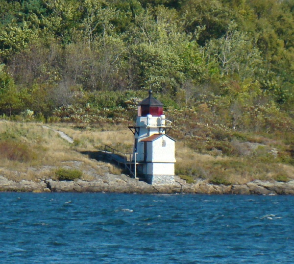
WOOD ISLAND LIGHT, ME. This 1808-built active, 47' round rubblestone tower with lantern and galley, painted white, is attached to a 2-story wood keeper’s house built in 1906. Its lantern and gallery are painted black, its fog horn sounds 2 blasts every 30 seconds. Its light is supplied by a VRB-25 aerobeacon installed in 1972 that has a focal plane of 71' above sea level, and alternating white and green flashes every 5 seconds. It was converted to solar power in 2001.
The lantern was removed in 1972 and rebuilt in 1986. It is Maine’s second oldest lighthouse, and the nation’s eleventh oldest. The bell tower was destroyed by a storm in the 1960s, but the 1872 bell was saved and is on display at Vine’s Landing in Biddeford Pool. Its 1903 stone oil house also survives on the site.
The Coast Guard leased the station to a chapter of the American Lighthouse Foundation in 2003. The volunteers cleared the site, removed debris from the tower, and restored electrical service to the lighthouse. A restoration plan has been prepared and submitted to the state for approval.
Located on an island off the mouth of the Saco River northeast of Biddeford Pool. Most
of the island is a wildlife sanctuary administered by the Maine Audubon Society. Owned by the U.S. Coast Guard; site manager: Friends of Wood Island Lighthouse.
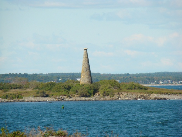
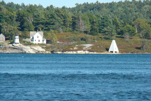
STAGE ISLAND MONUMENT, Biddeford Pool, ME. Web research supplied this information on the daymark shown here:
“Stage Island, where in the late 1800s the Biddeford Pool herring and cod fleets erected staging to dry their catches and where Wood Island keeper – Frank Verrill, had once lived. He also described the 60-foot stone “monument” built on the island in 1825, which still stands today as a navigational marker to aid the entry into the harbor.”
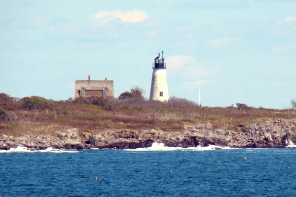
FORT POPHAM LIGHT, ME. Fort Popham, built during and for use in the Civil War in 1862--construction stopped in 1869 before the fort was finished, is on Route 209. The fort sits on the banks of the Kennebec River where it broadens into Atkins Bay, and offers views of Georgetown across the river. Designed to protect Bath shipyards and state capital further along the Kennebec River. The Union Army worried about the Confederacy’s newest naval ship design, the ironclad warship, and its possible effect on Bath Iron Works and Maine’s capital city of Augusta, which is located less than 20 miles up the Kennebec River. Built from granite blocks quarried on nearby Fox Island and Dix Island. It had a 30' high wall facing the mouth of the Kennebec River and was built in a crescent shape, measuring approximately 500' in circumference.
Fort Popham’s armament consisted of 36 cannons arrangedin2 tier of vaulted casements. Each cannon weighed roughly 25 tons and fired solid shot, each weighing almost 480 pounds. The back side of Fort Popham was built with a low moated curtain containing a central gate and 20 musket ports.
Modifications were made and the fort was used again in the Spanish American War and in World War 1. Historical records conclude that fortifications, probably wooden, existed here and protected the Kennebec settlements during the Revolutionary War and the War of 1812. It was nearby that the English made their first attempt to colonize New England in 1607.
Construction of Fort Baldwin on the headland above Fort Popham began in 1905 with longer-range guns, which eventually rendered Fort Popham obsolete.
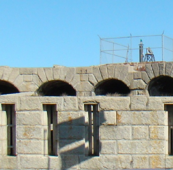
Research indicates there was a light on a spindle next to the fort in 1899; a light on top of a square pyramidal wooden structure that was on rocks in front of the fort in 1903, and the light shown here that was relocated to the top of the fort in the 1940s–still maintained by the U.S. Coast Guard. The fort is owned by the Maine Bureau of Parks and Lands, the site manager is the Fort Popham State Historic Site.
PERKINS ISLAND LIGHT, ME. Built in 1898, the station includes the 23' tall, octagonal wood and shingle lighthouse (the bracketed gallery was added in 1899), the 2-story wood-framed keeper’s dwelling and barn. Added in later years are the boathouse (1901), the pyramidal wooden bell tower (1902), and the brick oil house (1906).
Perkins Island’s original 5th-order Fresnel lens was removed in 1979 when the string of Kennebec River lights was automated. The lantern holds a modern 250 mm lens today, having a focal plane of 41' above sea level, showing a red flash every 2˝ seconds, 2 white sectors cover a clear channel. The station’s 1,000 pound fog bell is located on the grounds of the Georgetown High School.
The light station, except for the tower, was transferred to the state in the 1960s. The lighthouse is owned by the U.S. Coast Guard and leased in 2000 to the American Lighthouse Foundation (ALF). The keeper’s dwelling is the responsibility of the State of Maine but little has been done for this station. Except for a 2000 restoration of the fog bell tower by the Friends of Perkins Island Lighthouse, the ALF chapter formed when the lease occurred, the dwelling is boarded up and in very poor condition. The chapter hopes to work also for restoration of the keeper’s house. The tower is owned by the U.S. Coast Guard but leased to the American Lighthouse Foundation, the site by the Maine Department of Natural Resources.
SQUIRREL POINT LIGHT, ME. One of three similar light towers built in 1898. 25' tall, it is an octagonal wood-framed and shingle structure. The station’s 1˝-story wood-framed keeper’s dwelling is Victorian in design and has been privately restored. The garage and barn were also built in 1898. The brick oil house and boathouse were added in 1906. The light was automated in 1979; its original 5th-order Fresnel lens was removed and replaced by a plastic lens in 1980. The lens is displayed in the Museum at Portland Head Light.
Leased by a nonprofit organization, the Squirrel Point Light Associates, Inc. in 1996, the group had made improvements on the property and hoped to establish it as an educational center. The site is listed in the National Register of Historic Places.
In 2002 the lighthouse was listed for sale. When the Coast Guard indicated it would allow a sale to a retired naval office, a new group, Citizens for Squirrel point, sued to block the sale. The Coast Guard joined the suit and asked to recover the property because the owners had violated the terms of the 1996 transfer. A magistrate’s decision that the property should revert to the federal government was upheld in February of 2005. Located on Arrowsic island opposite Phippsburg. The site is open, the tower is closed. Owner/site manager: U.S. Coast Guard.