cf-banner.jpg
Previous Thread
Next Thread
Print Thread
OBX 4x4 Beach #180172 09/02/04 02:11 PM
Joined: Dec 2002
Posts: 3,298
seagirt Offline OP
Cruise Director
OP Offline
Cruise Director
Joined: Dec 2002
Posts: 3,298
When we were on the OBX, we took the Rover up the 4x4 beach in Corolla for our traditional dinner on the beach. There was a beautiful sunset...thought I might share the photos...

This is more of an art photo. I just saw the tire tracks going in all different directions and thought it would be a neat photo.


This is a Life Saving Station or LSS styled house near where we parked. If anyone can identify it, I'd appreciate it.


This is the sunset over the dune line....one of my favorite shots. Sorry that the quality isn't that great, the photo's better, but I wanted to compress it enough so that it wouldn't take too long to load. I'll make a page with the big photo so that those that want to can see it.


Finally...I hope that what this mirror has inscribed on its bottom is true! laugh


Re: OBX 4x4 Beach #180173 09/02/04 02:57 PM
Joined: Dec 1969
Posts: 7,893
Dave H Offline
Saint
Offline
Saint
Joined: Dec 1969
Posts: 7,893
I like the sunset picture, Greg. You did a nice job framing it with the dune grasses where they kind of dip to let the sun nestle in there.

Re: OBX 4x4 Beach #180174 09/06/04 02:25 PM
Joined: Jun 2001
Posts: 483
bonnebert Offline
Member
Offline
Member
Joined: Jun 2001
Posts: 483
I liked your pictures, Greg. Here's a link to lighthouses and lifesaving stations of the North Carolina coast. Maybe you can identify that lifesaving station by it's location on the map.

Lighthouses and Lifesaving Stations of NC Coast

Let us know if you figure it out.

Joyce

Re: OBX 4x4 Beach #180175 09/06/04 04:34 PM
Joined: Dec 2002
Posts: 3,298
seagirt Offline OP
Cruise Director
OP Offline
Cruise Director
Joined: Dec 2002
Posts: 3,298
Joyce, your link doesn't seem to be working...strange. I Googled NC Lifesaving Stations, and found all the pages from that site to be down. However, using Google's "view PDF as HTML" function, I was able to narrow it down a bit.

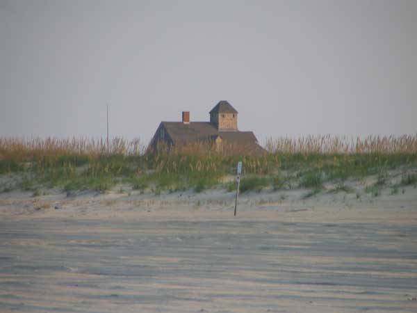
I know that Wash Woods is farther north than this, because after we ate, we went until we could see the border. There seem to be three south of Wash Woods but north of what seems to be the Duck border (I can only see the text with the numbers for the key of LSS names, but I am assuming where duck is...good thing the text is shaped like the OBX!)

Therefore, north-south, here are the possibilities. Photos are hard to come by, and anyway, most LSS are of a similar design, making it hard to figure out which is which. It could also just be a Faux LSS that they just did a really good job on.

Here's the list:

-Old Currituck Inlet (Pennys Hill)

-Jones Hill (Whalehead/Currituck Beach) (Interesting name... eek )

-Poyners Hill

I don't know exactly where we were...I know we were paralell to the Currituck NWR, which is all up in the 4x4 area. It's quite difficult...I can figure better when and if the site comes back up.


Forum Statistics
Forums39
Topics16,978
Posts184,640
Members2,579
Most Online10,155
Jan 14th, 2020
Who's Online Now
1 registered members (DANIEL), 1,345 guests, and 5 spiders.
Key: Admin, Global Mod, Mod
Newest Members
SafeHarbor, Toots, Bluffhill, phtate, TexLight2022
2579 Registered Users
Powered by UBB.threads™ PHP Forum Software 7.7.2